Weather Alert in South Carolina
Flood Advisory issued August 14 at 3:16PM EDT until August 17 at 8:00AM EDT by NWS Columbia SC
AREAS AFFECTED: Lexington, SC; Richland, SC
DESCRIPTION: ...The Flood Advisory continues for the following rivers in South Carolina... Congaree River At Congaree River at Columbia affecting Lexington and Richland Counties. * WHAT...Flooding caused by excessive rainfall continues. * WHERE...Congaree River at Congaree River at Columbia. * WHEN...Until Sunday morning. * IMPACTS...At 10.0 feet, Flooding occurs in flood prone areas near and downstream from Columbia. Flooding also occurs on parts of the Cayce and West Columbia river walk. * ADDITIONAL DETAILS... - At 3:00 PM EDT Thursday the stage was 11.3 feet. - Bankfull stage is 19.0 feet. - Forecast...The river is expected to fall to 6.2 feet Tuesday morning. - Action stage is 10.0 feet. - Flood stage is 19.0 feet. - http://www.weather.gov/safety/flood
INSTRUCTION: Caution is urged when walking near riverbanks. Additional information is available at www.weather.gov. The next statement will be issued late tonight at 330 AM EDT.
Want more detail? Get the Complete 7 Day and Night Detailed Forecast!
Current U.S. National Radar--Current
The Current National Weather Radar is shown below with a UTC Time (subtract 5 hours from UTC to get Eastern Time).

National Weather Forecast--Current
The Current National Weather Forecast and National Weather Map are shown below.

National Weather Forecast for Tomorrow
Tomorrow National Weather Forecast and Tomorrow National Weather Map are show below.

North America Water Vapor (Moisture)
This map shows recent moisture content over North America. Bright and colored areas show high moisture (ie, clouds); brown indicates very little moisture present; black indicates no moisture.

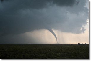
Weather Topic: What are Wall Clouds?
Home - Education - Cloud Types - Wall Clouds
 Next Topic: Altocumulus Clouds
A wall cloud forms underneath the base of a cumulonimbus cloud,
and can be a hotbed for deadly tornadoes.
Wall clouds are formed by air flowing into the cumulonimbus clouds, which can
result in the wall cloud descending from the base of the cumulonimbus cloud, or
rising fractus clouds which join to the base of the storm cloud as the wall cloud
takes shape.
Wall clouds can be very large, and in the Northern Hemisphere they generally
form at the southern edge of cumulonimbus clouds.
Next Topic: Altocumulus Clouds
Weather Topic: What are Altostratus Clouds?
Home - Education - Cloud Types - Altostratus Clouds
 Next Topic: Cirrocumulus Clouds
Altostratus clouds form at mid to high-level altitudes
(between 2 and 7 km) and are created by a warm, stable air mass which causes
water vapor
to condense as it rise through the atmosphere. Usually altostratus clouds are
featureless sheets characterized by a uniform color.
In some cases, wind punching through the cloud formation may give it a waved
appearance, called altostratus undulatus. Altostratus clouds
are commonly seen with other cloud formations accompanying them.
Next Topic: Cirrocumulus Clouds
Current conditions powered by WeatherAPI.com


