Weather Alert in Kentucky
Special Weather Statement issued February 23 at 5:08PM EST by NWS Jackson KY
AREAS AFFECTED: Fleming; Montgomery; Bath; Rowan; Estill; Powell; Menifee; Rockcastle; Jackson; Pulaski; Laurel; McCreary; Whitley; Knox; Elliott; Morgan; Johnson; Wolfe; Magoffin; Lee; Breathitt; Owsley; Clay
DESCRIPTION: Some light snow accumulations are anticipated this evening as scattered to numerous now showers track across the area. The snow showers will be most persistent east of I-75, however, portions of the Interstate 75 corridor between the KY and TN border and the Rockcastle and Madison county line may be affected. Wind gusts as high as 20 to 25 mph could occur in the heavier snow showers. This, when combined with the falling snow, may result in sudden sharp visibility reductions over short distances and quick light snow accumulations. Temperatures will be in the 20s and as the evening progresses, expect times of slick, slushy, or snow covered roads. Any untreated roads and surfaces, including bridges, overpasses, decks, and steps may be icy. If traveling this, slow down and exercise caution. Allow plenty of extra time to reach your destination.
INSTRUCTION: N/A
Want more detail? Get the Complete 7 Day and Night Detailed Forecast!
Current U.S. National Radar--Current
The Current National Weather Radar is shown below with a UTC Time (subtract 5 hours from UTC to get Eastern Time).

National Weather Forecast--Current
The Current National Weather Forecast and National Weather Map are shown below.

National Weather Forecast for Tomorrow
Tomorrow National Weather Forecast and Tomorrow National Weather Map are show below.

North America Water Vapor (Moisture)
This map shows recent moisture content over North America. Bright and colored areas show high moisture (ie, clouds); brown indicates very little moisture present; black indicates no moisture.

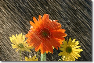
Weather Topic: What is Rain?
Home - Education - Precipitation - Rain
 Next Topic: Shelf Clouds
Precipitation in the form of water droplets is called rain.
Rain generally has a tendency to fall with less intensity over a greater period
of time, and when rainfall is more severe it is usually less sustained.
Rain is the most common form of precipitation and happens with greater frequency
depending on the season and regional influences. Cities have been shown to have
an observable effect on rainfall, due to an effect called the urban heat island.
Compared to upwind, monthly rainfall between twenty and forty miles downwind of
cities is 30% greater.
Next Topic: Shelf Clouds
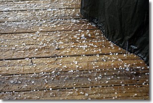
Weather Topic: What is Sleet?
Home - Education - Precipitation - Sleet
 Next Topic: Snow
Sleet is a form of precipitation in which small ice pellets are the primary
components. These ice pellets are smaller and more translucent than hailstones,
and harder than graupel. Sleet is caused by specific atmospheric conditions and
therefore typically doesn't last for extended periods of time.
The condition which leads to sleet formation requires a warmer body of air to be
wedged in between two sub-freezing bodies of air. When snow falls through a warmer
layer of air it melts, and as it falls through the next sub-freezing body of air
it freezes again, forming ice pellets known as sleet. In some cases, water
droplets don't have time to freeze before reaching the surface and the result is
freezing rain.
Next Topic: Snow
Current conditions powered by WeatherAPI.com


