Weather Alert in Kentucky
Special Weather Statement issued February 23 at 5:08PM EST by NWS Jackson KY
AREAS AFFECTED: Fleming; Montgomery; Bath; Rowan; Estill; Powell; Menifee; Rockcastle; Jackson; Pulaski; Laurel; McCreary; Whitley; Knox; Elliott; Morgan; Johnson; Wolfe; Magoffin; Lee; Breathitt; Owsley; Clay
DESCRIPTION: Some light snow accumulations are anticipated this evening as scattered to numerous now showers track across the area. The snow showers will be most persistent east of I-75, however, portions of the Interstate 75 corridor between the KY and TN border and the Rockcastle and Madison county line may be affected. Wind gusts as high as 20 to 25 mph could occur in the heavier snow showers. This, when combined with the falling snow, may result in sudden sharp visibility reductions over short distances and quick light snow accumulations. Temperatures will be in the 20s and as the evening progresses, expect times of slick, slushy, or snow covered roads. Any untreated roads and surfaces, including bridges, overpasses, decks, and steps may be icy. If traveling this, slow down and exercise caution. Allow plenty of extra time to reach your destination.
INSTRUCTION: N/A
Want more detail? Get the Complete 7 Day and Night Detailed Forecast!
Current U.S. National Radar--Current
The Current National Weather Radar is shown below with a UTC Time (subtract 5 hours from UTC to get Eastern Time).

National Weather Forecast--Current
The Current National Weather Forecast and National Weather Map are shown below.

National Weather Forecast for Tomorrow
Tomorrow National Weather Forecast and Tomorrow National Weather Map are show below.

North America Water Vapor (Moisture)
This map shows recent moisture content over North America. Bright and colored areas show high moisture (ie, clouds); brown indicates very little moisture present; black indicates no moisture.

Weather Topic: What is Drizzle?
Home - Education - Precipitation - Drizzle
 Next Topic: Evaporation
Drizzle is precipitation in the form of water droplets which are
smaller than raindrops.
Drizzle is characterized by fine, gently falling droplets and typically does not
impact human habitation in a negative way. The exception to this is freezing drizzle,
a condition where drizzle freezes immediately upon reaching earth's surface.
Freezing drizzle is still less dangerous than freezing rain, but can
potentially result in hazardous road conditions.
Next Topic: Evaporation
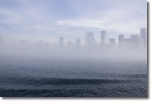
Weather Topic: What is Fog?
Home - Education - Cloud Types - Fog
 Next Topic: Fractus Clouds
Fog is technically a type of stratus cloud, which lies along the
ground and obscures visibility.
It is usually created when humidity in the air condenses into tiny water droplets.
Because of this, some places are more prone to foggy weather, such as regions
close to a body of water.
Fog is similar to mist; both are the appearance of water droplets suspended in
the air, but fog is the term applied to the condition when visibility is less than 1 km.
Next Topic: Fractus Clouds
Current conditions powered by WeatherAPI.com


