Weather Alert in Michigan
Special Weather Statement issued August 24 at 6:11PM EDT by NWS Gaylord MI
AREAS AFFECTED: Antrim
DESCRIPTION: At 611 PM EDT, Doppler radar was tracking a strong thunderstorm capable of producing a landspout over Torch Lake, or 9 miles north of Elk Rapids, moving southeast at 25 mph. HAZARD...Landspouts, wind gusts up to 40 mph, and half inch hail. SOURCE...Radar indicated. IMPACT...Minor damage to outdoor objects is possible. Gusty winds could knock down tree limbs and blow around unsecured objects. This strong thunderstorm will be near... Elk Rapids, Bellaire, Central Lake, Kewadin, Clam River, and Alden around 615 PM EDT. Mancelona and Antrim around 635 PM EDT. Other locations impacted by this storm include Lake Bellaire.
INSTRUCTION: If outdoors, consider seeking shelter inside a building. Conditions are favorable for the development of weak, brief funnel clouds. This type of funnel cloud is harmless, but on rare occasions they can briefly touch down, producing wind gusts over 50 mph. If a funnel cloud is spotted move indoors and report your sighting to the National Weather Service.
Want more detail? Get the Complete 7 Day and Night Detailed Forecast!
Current U.S. National Radar--Current
The Current National Weather Radar is shown below with a UTC Time (subtract 5 hours from UTC to get Eastern Time).

National Weather Forecast--Current
The Current National Weather Forecast and National Weather Map are shown below.

National Weather Forecast for Tomorrow
Tomorrow National Weather Forecast and Tomorrow National Weather Map are show below.

North America Water Vapor (Moisture)
This map shows recent moisture content over North America. Bright and colored areas show high moisture (ie, clouds); brown indicates very little moisture present; black indicates no moisture.

Weather Topic: What is Snow?
Home - Education - Precipitation - Snow
 Next Topic: Stratocumulus Clouds
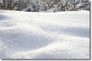
Snow is precipitation taking the form of ice crystals. Each ice crystal, or snowflake,
has unique characteristics, but all of them grow in a hexagonal structure.
Snowfall can last for sustained periods of time and result in significant buildup
of snow on the ground.
On the earth's surface, snow starts out light and powdery, but as it begins to melt
it tends to become more granular, producing small bits of ice which have the consistency of
sand. After several cycles of melting and freezing, snow can become very dense
and ice-like, commonly known as snow pack.
Next Topic: Stratocumulus Clouds
Weather Topic: What are Stratus Clouds?
Home - Education - Cloud Types - Stratus Clouds
 Next Topic: Wall Clouds
Stratus clouds are similar to altostratus clouds, but form at a
lower altitude and are identified by their fog-like appearance, lacking the
distinguishing features of most clouds.
Stratus clouds are wider than most clouds, and their base has a smooth, uniform
look which is lighter in color than a nimbostratus cloud.
The presence of a stratus cloud indicates the possibility of minor precipitation,
such as drizzle, but heavier precipitation does not typically arrive in the form
of a stratus cloud.
Next Topic: Wall Clouds
Current conditions powered by WeatherAPI.com


