Weather Alert in Florida
Special Weather Statement issued March 3 at 5:41PM EST by NWS Jacksonville FL
AREAS AFFECTED: Coastal Nassau; Coastal Duval; Coastal Flagler; Northeast Coastal St. Johns; Southeast Coastal St. Johns; Northern Inland St. Johns; Southern Inland St. Johns; Coastal Glynn; Coastal Camden
DESCRIPTION: Sea fog is developing as low stratus clouds settle to the ground from the coast and intracoastal waters towards I-95 with locations at Craig airfield, Fernandina Beach, and Mayport reporting visibility around 1 mile. The sea fog will occasionally reduce visibilities to under 1 mile through sunset and the early evening hours. Dense sea fog will likely expand inland during the early to mid evening hours, when Dense Fog Advisories will likely be re-issued for all of coastal southeast Georgia and coastal northeast Florida. Motorists should remain alert for sudden changes in visibility this afternoon, particularly along coastal roads such as A-1A in northeast Florida and U.S. Highway 17 in southeast Georgia. If you encounter sea fog while driving in these coastal locations this afternoon, slow down and leave extra distance ahead of you in case a sudden stop is needed.
INSTRUCTION: N/A
Want more detail? Get the Complete 7 Day and Night Detailed Forecast!
Current U.S. National Radar--Current
The Current National Weather Radar is shown below with a UTC Time (subtract 5 hours from UTC to get Eastern Time).

National Weather Forecast--Current
The Current National Weather Forecast and National Weather Map are shown below.

National Weather Forecast for Tomorrow
Tomorrow National Weather Forecast and Tomorrow National Weather Map are show below.

North America Water Vapor (Moisture)
This map shows recent moisture content over North America. Bright and colored areas show high moisture (ie, clouds); brown indicates very little moisture present; black indicates no moisture.

Weather Topic: What is Freezing Rain?
Home - Education - Precipitation - Freezing Rain
 Next Topic: Graupel
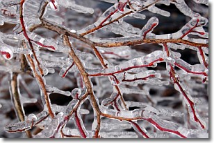
Freezing rain is a condition where precipitation which has fallen in the form of
water droplets reaches temperatures which are below freezing and freezes upon
coming into contact
with surface objects. The result of this precipitation is a glaze of ice which
can be damaging to plants and man-made structures. A severe onset of freezing
rain which results in a very thick glaze of ice is known as an ice storm.
Next Topic: Graupel
Weather Topic: What is Hail?
Home - Education - Precipitation - Hail
 Next Topic: Hole Punch Clouds
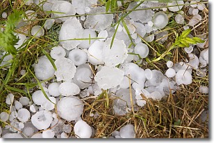
Hail is a form of precipitation which is recognized by large solid balls or
clumps of ice. Hail is created by thunderstorm clouds with strong updrafts of wind.
As the hailstones remain in the updraft, ice is deposited onto them until their
weight becomes heavy enough for them to fall to the earth's surface.
Hail storms can cause significant damage to crops, aircrafts, and man-made structures,
despite the fact that the duration is usually less than ten minutes.
Next Topic: Hole Punch Clouds
Current conditions powered by WeatherAPI.com


